using maps

grid maps and story maps*
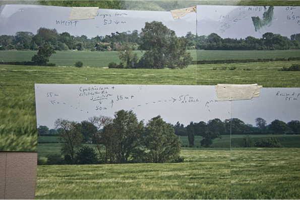
This detail is from a large scale Ordnance map with five meter contours and spot heights. Pencil lines mark the boundaries of the view used in another painting - the angle of vision is about 160˚and extends roughly ENE to SSW. The red cross marks where I sat for 'Spring'. Moral : if you take the right attitude there's plenty of buried treasure in the world.
Plotted against photographs (below) contours and spot heights helped me to articulate the topography. This is particularly useful in a flat landscape where landscape features are not obvious. The ordnance grid map helped me to make my own story map of this place in paintings.
The photos were taken in a year with Barley as the crop because that was the time I decided to plot the horizon. I had to wait until wheat came back round in the rotation to do the final studies for Spring; but that did not matter as I wanted to align myself with the timescale of the farm, and there were plenty of other things for me to work on.
Though I didn't know it at the time, local historian and writer Ronald Blythe lives a few minutes walk from this field, in a house that once belonged to the painter John Nash, Bottengoms. I've now been lucky enough to meet Ronnie several times and its been a pleasure and privilege to know him, not least because of his association with the farmer-poet John Clare. I feel this wonderful tradition justifies my taking so much care with only a small patch of land.